| Back to Daelnet » home | news | directory | features | gallery |
||
 |
 |
|
| p e n - y - g h e n t | <«· intro |
|
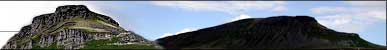
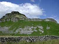
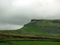
geology Pen-y-ghent, like Ingleborough, is built up mainly of carboniferous limestone and millstone grit, though in differing proportions. The millstone grit cap rests upon the main limestone, followed by the limestones, sandstones and shales of the yoredale beds or series. The great scar limestone follows, resting unconformably above the silurian slates.  views Looking north, trains can be seen moving northwards from Horton towards Whernside and Blea Moor. Langstrothdale, Cam Fell, Dodd Fell and Widdale Fell also come into view. Ingleborough, Simon Fell and Moughton Fell lie to the west, whilst Attermire Crags, Ryeloaf, and further on, Pendle Hill are viewed to the south. To the east come Littondale Head, Yockenthwaite Moor and closer still Halton Gill and Litton. |
|||||||||||||||||||||||||||
|
|
||
|
webcraft by q u a n t u m d o t k n o w l e d g e Copyright 1995-2001 QDK Ltd |
||